
- August 19, 2019
- Places
- inndawgyi lake, natural heritage sites
Natural Heritage sites in Myanmar
Natural Heritage sites in Myanmar
Myanmar is located beautifully in the South East Asia with mountains ranges, snowcapped Mountains in the northern most region, forests, and beautiful beaches and archipelagos along the western and southern coastal regions. Myanmar still does not have any natural World Heritage sites, yet there are several sites with high potential. However, two natural heritage sites, Nat Ma Taung National Park in Chin State and the Indawgyi Lake Wildlife Sanctuary in Kachin State, have been recommended as priority candidates for future nomination to Unesco’s World Heritage List. Myanmar is now taking an important step forward in protecting its natural heritage in accordance with World Heritage standards in order to maintain its natural environment, to develop the surrounding community as well as to promote tourism.
- Nat Ma Taung National Park
Rising from the surrounding Chin Hills, Nat Ma Taung National Park is renowned for its extreme elevation gradient and great beauty. Serving as a refuge during the last glacial period, the site is an alpine “sky island” with a diversity of Himalayan flora and is home to more than 800 plant species, including a rich variety of orchids, and several endemic bird species.
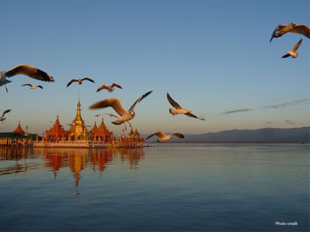
- Indawgyi Lake
Indawgyi Lake is one of the largest lakes in Southeast Asia. It provides a habitat for 10 globally threatened bird species and is of outstanding value for conservation of migrating waterbirds. The lake also contains important endemic fish and turtle species, such as the Burmese Peacock Turtle.
- The Northern Forest Mountain Complex
Hkakabo Razi is Burma’s probably highest mountain, and with its height of 5,881 m (19,295 ft) the probable highest mountain in South East Asia. It is located in the northern Myanmar state of Kachin in an outlying subrange of the Greater Himalayan mountain system near the border tri-point with India and China. Its highest status has recently been challenged by Gamlang Razi, 6.6 km WSW on the Chinese border. The peak is enclosed within Hkakabo Razi National Park. Hkakabo Razi was established as a natural reserve on January 30, 1996 and as a national park on November 10, 1998. The Khakaborazi National Park is the last stronghold for biodiversity in Myanmar. Extraordinarily rich flora and fauna, ranging from lowland tropical to alpine species still await proper research and identification. They have barely been studied, and the park remains an excellent center for field study for students of botany, geology, zoology and geography.
- The Myeik Archipelago
The Mergui Archipelago is an archipelago in far southern Myanmar (Burma) and is part of the Tanintharyi Region. It consists of more than 800 islands, varying in size from very small to hundreds of square kilometres, all lying in the Andaman Sea. The islands are characterized mainly by limestone and granite. They are generally covered with thick tropical growth, including rainforest, and their shorelines are punctuated by beaches, rocky headlands, and in some places, mangrove swamps. Offshore are extensive coral reefs.
The archipelago’s virtual isolation from most of mankind’s influence on the natural environment has given the islands and the surrounding waters of the Andaman Sea a great diversity of flora and fauna, contributing to the region’s growing popularity as a diving destination, representing endangered megafaunas such as whale sharks and dugongs.
On the islands themselves, various animals thrive, including deer, monkeys, tropical birds including hornbills, and wild swine. There are even unconfirmed reports of Sumatran rhinoceros on Lanbi, one of the bigger islands, but this has been widely discredited.
- The Hukaung Valley Wildlife Sanctuary
Hukawng Valley Tiger Reserve is a wildlife reserve located in Hukawng Valley, near Tanai in Myitkyina District of Kachin State, Burma (Myanmar) and an important habitat for globally threatened wildlife, notably tigers and Asian elephants. Hukawng Valley Tiger Reserve covers 21890 km². The Burmese government has also designated 6500 km² of the valley as the protected forest reserve. It is the world’s largest tiger reserve.
- The Tanintharyi Forest Corridor
The Tanintharyi Nature Reserve is a nature reserve in the Tenasserim Hills, Burma, north of Tanintharyi National Park on the border with Thailand, adjacent to Kaeng Krachan National Park. It is the largest remaining lowland evergreen forest in mainland Southeast Asia and governed by the Burma Forest Department and the level of protection is partial. Elevations within the reserve range from 20–1,300 m. Tourists are not permitted within the nature reserve.
- The Ayeyawaddy River Corridor
The Ayeyawady River Corridor covers a 400 km stretch of one of the last major undammed rivers in Asia. Tributaries originating high in Myanmar’s northern mountains flow south before joining northeast of Myitkyina to form the Ayeyawady River. The river basin lies almost entirely within Myanmar and covers nearly 60% of its land surface. Above the city of Mandalay until Bhamo, the river is home to the globally VU Irrawaddy Dolphin. The Irrawaddy Dolphin in this river is famous for its cooperative fishing behavior with humans. The Ayeyawaddy River Corridor provides habitat for these dolphins, as well as for other wildlife including the White-bellied Heron and several species of globally threatened turtle.